SHARA MOUNTAIN
 Shara Mountain is situated in the north western part of the Republic of Macedonia. The massif extends from the northeast, through the west, continuing to the southwest for 80km with a total surface area of 1600km2. The approximate height of the mountain range is 2200m. It begins with the Lepenec River and respectively with the peak of Ljuboten, 2499m. It ends with Morava, 2147m, accurately with the spring of the river Vardar, Vrutok. Shara Mountain is situated in the north western part of the Republic of Macedonia. The massif extends from the northeast, through the west, continuing to the southwest for 80km with a total surface area of 1600km2. The approximate height of the mountain range is 2200m. It begins with the Lepenec River and respectively with the peak of Ljuboten, 2499m. It ends with Morava, 2147m, accurately with the spring of the river Vardar, Vrutok.
Shara Mountain massif belongs to a group of young mountain chains and is characterized by mountainous climate with cold winters and pleasant summers. The approximate average temperature in winter is -1.5oC and in the summer 17oC. At an elevation of 1300m the snow averages a depth of 1m. The snow usually lasts for 4 months. Winds mostly blow from the north-west.
The massif is covered with very rich flora and fauna. It has an abundance of high pasture ground lands of 45000 ha. and high-trunk conifer woods. Fir trees and juniper trees are most common, and in the lower parts beech wood and chestnut wood are abundant. There are over 200 species of endemic plants on Shara Mountain which is the highest percentage of endemism in the R. Macedonia. Over 44 species of game are present on this mountain including the lynx, the bear, the wild goat and the wild boar. Eagles, falcons, and hawks are also common on Shara Mountain. We are proud to mention that the dog Sharplaninec is a very rare shepherd dog.
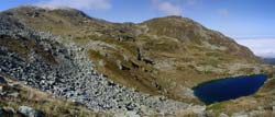
The Eyes of Shara Mountain are glacial lakes that are special characteristics of Shara Mountain. There are 25 lakes that are constant, over 150 occasional lakes, as well and 150 pools. The water potential of this massif is huge and it has 200 springs of pure water. There are also minerals presents such as manganese, iron, chrome, molybdenum, and copper.
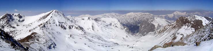
On Shara Mountain there are a large number of peaks over 2200m in height. Starting from the north-west side of the massif they are: Ljuboten (2499м.), Livadica (2497м.), Piribeg (2524м.), Chaushica (2651м.), Bistrica (2571м.), Crn Vrv (Black Peak) (2585м.), Kobilica (2528м.), Vrtop (2555м.), Karanikola (2409м.), Skakalo (2493м.) that go down through Babaasanica to the most beautiful and most attractive part of this massif, Lesnica (1450м.). From Lesnica you can climb to the highest peak on Shara Mountain, Titov Vrv (2747м.). Around this peak there are several more peaks such as Ceripashina (2525м.), Sin Vrv (Blue Peak) (2550м.), Kazani (2567м.), Bakardan (2704м.) and Mal Turcin (2702м.). Continuing, the peaks are: Dzinibeg (2610м.), Trapeznica (2590м.), Borislaec (2675м.), and Rudoka (2658м.), Golema Vraca (Big Vraca) (2582м.), Peak of Radika (2405м.), Rasengul (2386м.), Lera (2194м.) and Morava (2147м.) that slightly goes down.
Shara Mountain provides a huge potential for the development of mountain sports. Skiing, mountaineering, alpinism, mountain tracking, mountain biking, paragliding, sport hunting, sport fishing, as well as the potential for building a new ski centers are all opportunities ripe for development . For now the only ski center on Shara Mountain is Popova Shapka. It is situated in the middle of this massif above the city of Tetovo in the cradle below Ceripashina. The Popova Shapka ski center is 30km2. Others areas of this massif yield the potential for the development of a ski center, such as: the area of Ljuboten-Livadica, the areas of Piribeg, Kobilica, Leshica-Jelak, the area of Vakuf and Borislaec. These areas can also be used for the development of mountaineering and all of the above mentioned sports. |